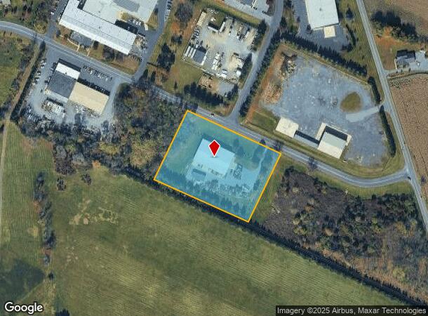
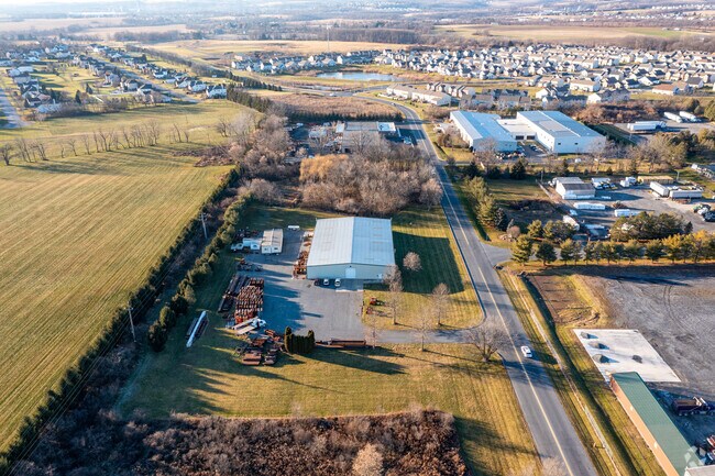
Property Record
587 Gremar Rd, Nazareth, PA 18064


NEARBY LISTINGS FOR SALE OR LEASE
Property Detail
587 Gremar Rd
K7-19-14B-1A-0418
Minor Subdivision Of The Land Of Clarenc
Industrialpark
Northampton
X
Pennsylvania
42095C0255E
3.43 AC
2025
Lehigh Valley
2025
Philadelphia
016902
Allentown-Bethlehem-Easton, PA-NJ
15,540 SF
DEMOGRAPHICS near 587 Gremar Rd
1 Mile
3 Mile
5 Mile
2024 Total Population
3,434
26,274
98,519
2029 Population
3,512
26,599
99,280
Pop Growth 2024-2029
+ 2.27%
+ 1.24%
+ 0.77%
Average Age
42
44
44
2024 Total Households
1,132
9,188
37,399
HH Growth 2024-2029
+ 2.30%
+ 0.90%
+ 0.72%
Median Household Inc
$114,536
$90,604
$96,055
Avg Household Size
2.90
2.50
2.50
2024 Avg HH Vehicles
2.00
2.00
2.00
Median Home Value
$351,777
$325,233
$292,455
Median Year Built
1996
1977
1982
Nearby Places
Map Layers
Map Styles
 Street
 Aerial
- Restaurants
- Banks
- Shops
- Fitness
- Groceries
PUBLIC TRANSPORTATION
AIRPORT
Lehigh Valley International
DRIVE
WALK
Distance
Lehigh Valley International
17 min
9.7 mi
Freight Ports
Port of Philadelphia
DRIVE
WALK
Distance
Port of Philadelphia
98 min
74.3 mi
SALE & LEASE HISTORY
LISTING DATE
SALE/LEASE

Sep 28, 2018
For Sale
Dec 10, 2019
For Lease
Nearby Properties
Address
Land Use
TOTAL SIZE
Lot Size
Zoning
Address
Land Use
TOTAL SIZE
Lot Size
Zoning
605,906 SF
94.28 AC
A
Address
Land Use
TOTAL SIZE
Lot Size
Zoning
1,001,315 SF
68.62 AC
I
Address
Land Use
TOTAL SIZE
Lot Size
Zoning
1,080,846 SF
74.80 AC
I
Address
Land Use
TOTAL SIZE
Lot Size
Zoning
302,378 SF
83.53 AC
A
Address
Land Use
TOTAL SIZE
Lot Size
Zoning
205,594 SF
61.99 AC
C
Address
Land Use
TOTAL SIZE
Lot Size
Zoning
82.80 AC
I2
Address
Land Use
TOTAL SIZE
Lot Size
Zoning
52,164 SF
124.81 AC
IN
Address
Land Use
TOTAL SIZE
Lot Size
Zoning
344,973 SF
42.25 AC
PIC
Address
Land Use
TOTAL SIZE
Lot Size
Zoning
533,165 SF
54.66 AC
LI/BP
Address
Land Use
TOTAL SIZE
Lot Size
Zoning
524,948 SF
35.66 AC
LI
Address
Land Use
TOTAL SIZE
Lot Size
Zoning
249,872 SF
41.83 AC
PC
Address
Land Use
TOTAL SIZE
Lot Size
Zoning
512,902 SF
35.18 AC
LI
Address
Land Use
TOTAL SIZE
Lot Size
Zoning
601,903 SF
41.68 AC
LI
Address
Land Use
TOTAL SIZE
Lot Size
Zoning
539,133 SF
47 AC
LI
Address
Land Use
TOTAL SIZE
Lot Size
Zoning
1,456 SF
29.36 AC
A
Address
Land Use
TOTAL SIZE
Lot Size
Zoning
437,612 SF
42.26 AC
LI/BP
Address
Land Use
TOTAL SIZE
Lot Size
Zoning
472,529 SF
43.86 AC
A
Address
Land Use
TOTAL SIZE
Lot Size
Zoning
130,145 SF
21.19 AC
R3
Address
Land Use
TOTAL SIZE
Lot Size
Zoning
508,835 SF
34.92 AC
A
Address
Land Use
TOTAL SIZE
Lot Size
Zoning
8,390 SF
126.60 AC
I
Address
Land Use
TOTAL SIZE
Lot Size
Zoning
244,478 SF
26.32 AC
LI
Address
Land Use
TOTAL SIZE
Lot Size
Zoning
307,425 SF
37.13 AC
A
Address
Land Use
TOTAL SIZE
Lot Size
Zoning
257,186 SF
14.63 AC
G1
Address
Land Use
TOTAL SIZE
Lot Size
Zoning
111,271 SF
15.32 AC
C
Address
Land Use
TOTAL SIZE
Lot Size
Zoning
229,448 SF
12.95 AC
GI
Address
Land Use
TOTAL SIZE
Lot Size
Zoning
312,950 SF
33.17 AC
A
Address
Land Use
TOTAL SIZE
Lot Size
Zoning
135,293 SF
38 AC
C
Address
Land Use
TOTAL SIZE
Lot Size
Zoning
227,807 SF
12.09 AC
GI
Address
Land Use
TOTAL SIZE
Lot Size
Zoning
59,583 SF
3.87 AC
C
Address
Land Use
TOTAL SIZE
Lot Size
Zoning
207,393 SF
15.28 AC
LI
The World's #1 Commercial Real Estate Marketplace
Connect with us
© 2025 CoStar Group
The information above has been obtained from sources believed reliable. While we do not doubt its accuracy we have not verified it and make no guarantee, warranty or representation about it. It is your responsibility to independently confirm its accuracy and completeness. Any projections, opinions, assumptions, or estimates used are for example only and do not represent the current or future performance of the property. The value of this transaction to you depends on tax and other factors which should be evaluated by your tax, financial, and legal advisors. You and your advisors should conduct a careful, independent investigation of the property to determine to your satisfaction the suitability of the property for your needs.